
Digitalisation, GIS & Earth Observation Systems
NIRAS has the capability to use a wide range of digital solutions – like forest information systems, earth observation technologies and artificial intelligence – to support improved governance and inclusive decision making of natural resources. NIRAS collaborates with institutional partners to build capacity and enable the collection, analysis and use of high-quality data. We use remotely sensed data to develop land use change analysis, explore options and scenarios, carry out ecosystem services valuation assessments and inform forest information systems (FIS). Our Earth observation and GIS competencies encompass cartography, mapping and visualisation, spatial analysis, digitising and modelling, data management and analysis, as well as the calibration and validation of satellite-derived data.
NIRAS delivers a wide range of specialised digitalisation services in the forestry and land sectors, including:
- Automating real-time monitoring of biodiversity and forest-related metrics, including land use change and socioeconomic metrics, using a wide range of technologies (e.g. remote sensing, geographical information systems, drones, ground-based sensors);
- Digital solutions for forest-based value chain development of timber and non-timber forest products;
- Application of frontier technologies for automating processes and decision making (e.g. artificial intelligence, block-chain, sensors and internet-ofthings);
- Forest and biodiversity information systems, development of bespoke systems supporting real-time decision-making using cloud-based technologies for data storage and sharing;
- Advanced data science analysis skills to automate the processing and analysis of new large environmental and social data sources;
- Mapping and optimising conservation planning for terrestrial and aquatic environments using GIS and optimisation algorithms respectively;
- Digital solutions for enhancing environmental education, training, capacity building and awareness raising; and
- Platforms to strengthen business models for conservation, linking buyers and sellers (e.g. payment for ecosystem services, REDD+).
Read about NIRAS’ Digitalisation capabilities for the development sector in the link below.
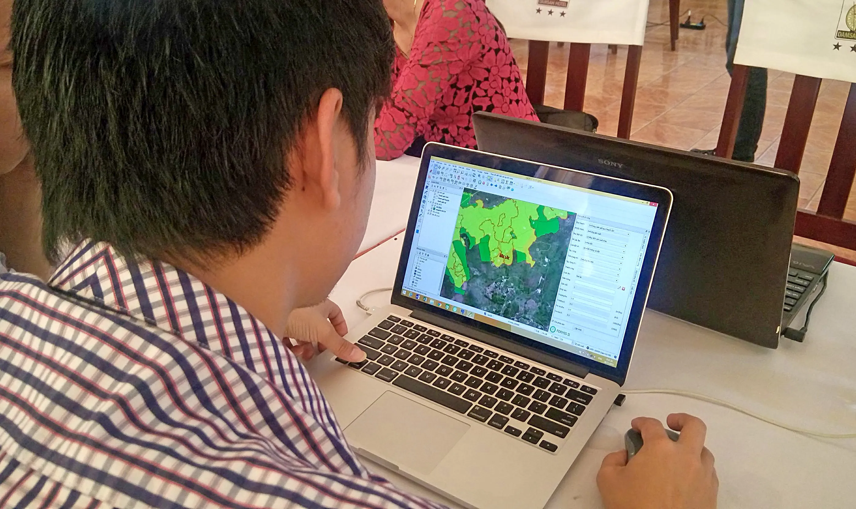
Management Information System for the Forestry Sector in Vietnam (FORMIS)
FUNDER
MFA Finland & Government of Vietnam
DURATION
Phase I: 2009-2013;
Phase II: 2013-2018
CONTRACT VALUE
EUR 9.7M
In the FORMIS project, NIRAS established a management information system for Vietnam's forestry sector, supporting sector-wide forest governance and decision-making. The system integrated all forest related Earth observation and attributed data previously scattered in various organisations in a centralised platform through cloud technology and service-oriented architecture, including agroforestry and forest conversion due to agricultural activities. Users can generate informed forest resource monitoring reports based on emerging needs as the technology allows for real-time data. Through the two phases of the project, activities were scaled up to provide up-to-date forest resource data which can now be used for effective forest management and supporting the reduction of emissions from deforestation and forest degradation (REDD) as well as forest law enforcement, governance, and trade (FLEGT) activities. The use of the system is now written intonational policy and is being used by over 750 forest administration agencies in 60 provinces of Vietnam.
FORMIS integrated all forest-related Earth observation and attributed data previously scattered in various organisations in a centralised platform through cloud technology and service - oriented architecture, including agro-forestry and forest conversion due to agricultural activities.
Satellite Monitoring for Forest Management (SMFM)
FUNDER
World Bank
DURATION
2016 - 2020
CONTRACT VALUE
EUR 981K
The SMFM project aimed to improve global knowledge and capabilities for forest degradation assessment and monitoring dry forest landscapes by building upon and complimenting existing international programmes. Funded by the World Bank and the European Space Agency, SMFM supported selected countries in developing their Earth observation capacity. NIRAS tested new or improved methods to process and analyse new satellite Earth observation datasets, with assessments of Earth observation processing methods completed through practical implementation in Mozambique, Namibia and Zambia. SMFM developed methods and open access tools for monitoring of dry forests with Earth observation data, including data pre-processing and compositing, biomass and biomass change mapping, time series analysis, and mapping drivers of deforestation. The project provided technical assistance to national government staff through remote support, training materials, and provision of capacity building workshops.

