
Land
NIRAS offers an extensive range of services aimed at fostering effective land tenure regimes, sustainable land management, and effective governance. We support governments in the development of cost-effective land administration systems that meet national objectives and conform to international standards. These systems are adjusted to local conditions and developed within the capabilities of the country’s national administration.
With our public, private, and civil society partners, NIRAS aims to ensure that land tenure and management contribute to reducing poverty, enhancing livelihoods, strengthening investment opportunities, guaranteeing sound environmental management, contributing to social inclusion and justice, empowering women and reducing conflict.
Land Governance & Institutional Capacity Building
NIRAS assists governments in revising and updating land policies and laws. Effective land governance enables investment, economic growth and social stability. NIRAS also strengthens institutional frameworks, enhances administrative capabilities, and improves governance within the land sector. Supporting reform, improving institutional structures, and enhancing human resource development enables an efficient and transparent land management system to meet the needs of citizens. NIRAS also supports the development of education systems that enhance knowledge and skills in land management. Our initiatives include the creation of curricula, training programmes, and educational materials that build local capacity and expertise.

Responsible Investment and Governance in Land (RGIL)
FUNDER
GIZ
DURATION
2020 - 2023
CONTRACT VALUE
EUR 1.3M
As part of the its Global Programme Responsible Land Policy, GIZ contracted NIRAS to deliver services to support the RGIL project, which aimed to contribute to increased agricultural productivity and development in Ethiopia, Lao PDR and Uganda. NIRAS' role in the project was to strengthen the capacities of: (1) government authorities to administer and guide investments in land in accordance with established legislation and recognised principles such as the Voluntary Guidelines on the Responsible Governance of Tenure of Land, Fisheries and Forests in the context of national food security as well as responsible agricultural investment; (2) investors to comply with internationally recognised principles for responsible investments inland; and (3) local land users, especially smallholders and vulnerable groups to defend their legitimate rights to land and advocate for their needs in land investment processes.
Land Rights & Registration
Land conflicts can hinder development and disrupt social harmony. NIRAS ensures that the legitimate tenure rights of women and men are recognised on an equal basis and that tenure rights of the most vulnerable populations are respected. Gender and social inclusion are integral to our approach. We ensure that land policies, laws, and practices are inclusive, promoting the rights and participation of women, indigenous peoples, and other marginalised groups in land governance. Our services include the assessment of investment impacts and the implementation of safeguards to protect community rights and natural resources.
Responsible and Innovative Land Administration in Ethiopia (REILA I, II, III)
FUNDER
Ministry for Foreign Affairs Finland
DURATION
2011 - 2028
CONTRACT VALUE
EUR 30.8M
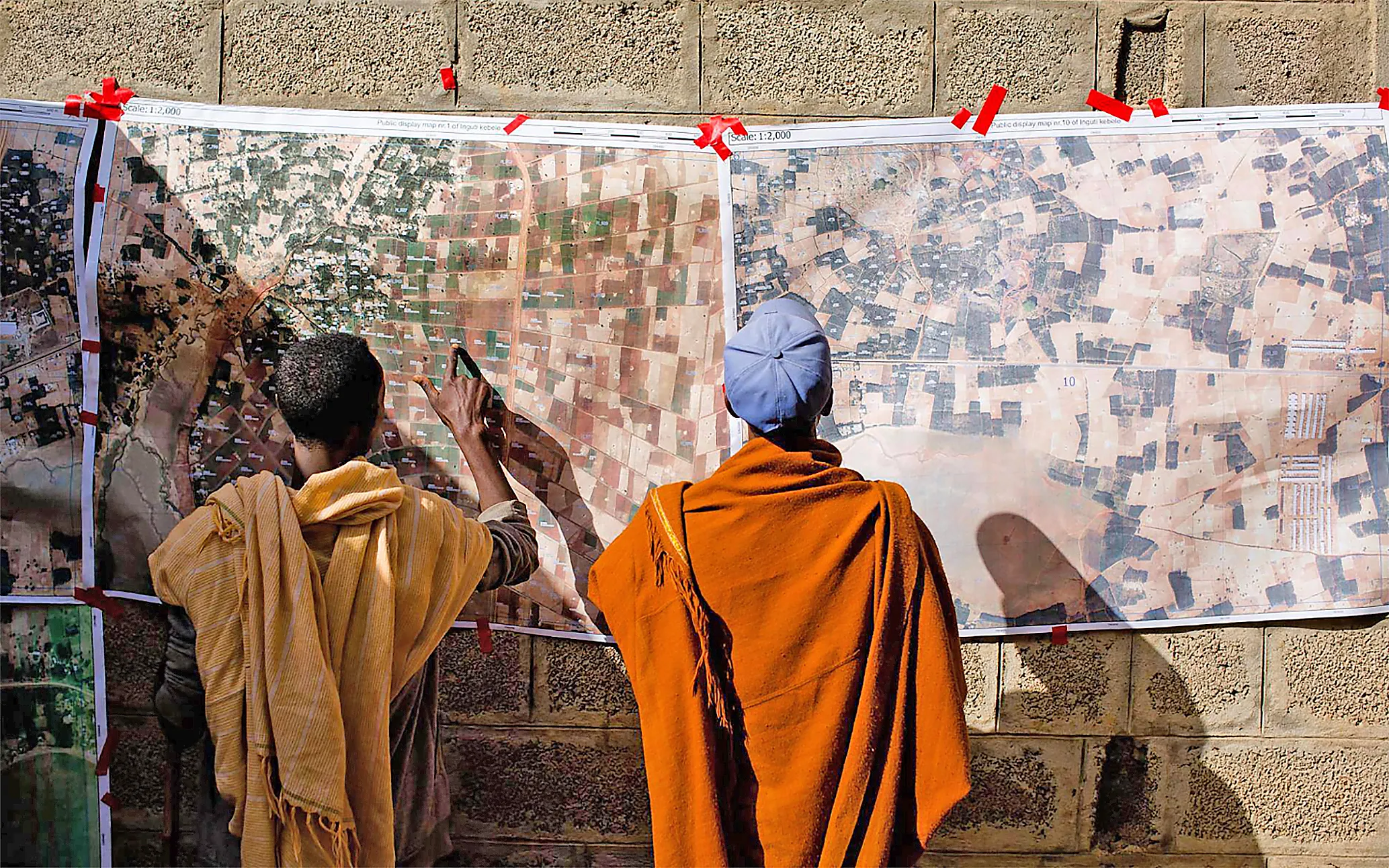
For over 25 years, NIRAS has been centrally involved in developing Ethiopia’s land administration system. Since 2011, NIRAS has managed the three phases of the Finnish-funded REILA project, which has succeeded in establishing an efficient, transparent, and equitable system for land registration for Ethiopia. The REILA project's first phase improved land administration in Amhara and Benishangul-Gumuz, leading to the government adopting REILA’s system nationwide for registering over 50 million rural land parcels. The project also saw massive gains in terms of IT infrastructure in the form of the National Land Administration Information System (NRLAIS), which stores official land holding data, handles systematic land registration and manages continuous land transactions. REILA has offered on-the-job training and technical training to various government employees in the land administration sector and over 1,400 government employees have been trained in the use and administration of NRLAIS. Part of the equitable distribution of land involves ensuring that parcels are registered to women as well as men, preventing discrimination and ensuring women’s full and effective participation in the process. Of the approximately 1.2 million land parcels registered during REILA phase II, 77% were registered to women, either jointly within marriage or to female-headed households. This development represents a significant distribution of wealth to those women, which in turn offers them a huge improvement in their livelihoods and their families’ welfare.
1,400
government employees
have been trained in the use and administration of the National Land Administration Information System
1.2
million land parcels registered during REILA phase II
77%
were registered to women
Participatory Mapping & Planning (PMaP) 4 and 8
FUNDER
Millenium Challenge Account
DURATION
2016 - 2018
CONTRACT VALUE
EUR 9.6M
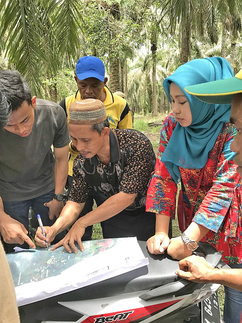
Under the Green Prosperity Project in Indonesia, NIRAS implemented PMaP 4 and 8 to improve land use security and increase adherence to spatial plans by investors, governments and communities. PMaP 4 built the capacity of government agencies in spatial planning, enforcement, and management of land use information in spatially enabled databases. In PMaP 8, the team mapped the boundaries of 82 villages in Riau Province in a very short span of 10.5 months. Attention was given to the participation of women and disadvantaged groups. In addition to generating spatial data, the process also resolved land conflicts and demarcated agricultural areas and land required for natural resource management. Our support enabled (1) increased efficiency of the permit and licensing process; (2) reduced conflicts between and among adjacent villages; and (3) enhanced public perception of transparency and fairness in the permit and licensing processes.
PMaP 4 built the capacity of government agencies in spatial planning, enforcement, and management of land use information in spatially-enabled databases. In PMaP 8, the team mapped the boundaries of 82 villages in Riau Province in a very short span of 10.5 months. Attention was given to the participation of women and disadvantaged groups.
Development of Land Information Systems
Land conflicts can hinder development and disrupt social harmony. NIRAS ensures that the legitimate tenure rights of women and men are recognised on an equal basis and that tenure rights of the most vulnerable populations are respected. Gender and social inclusion are integral to our approach. We ensure that land policies, laws, and practices are inclusive, promoting the rights and participation of women, indigenous peoples, and other marginalised groups in land governance. Our services include the assessment of investment impacts and the implementation of safeguards to protect community rights and natural resources.
.webp)
A Common Mapping Platform & Methodology for Local Land Use Planning in Cameroon
FUNDER
European Forest Institute (EFI)
DURATION
2017 - 2018
CONTRACT VALUE
EUR 224K
EFI contracted NIRAS to design, build and test a common mapping platform to improve the transparency of spatial planning in Cameroon, focussing on providing information and tools that can support the participatory preparation of local land use and sustainable development plans at the municipal level. The online information system made available various types of topographical and land use information to those who need it during multi-stakeholder land use planning and fostered a common understanding between relevant ministries, regional delegations, civil society and private sector organisations around the data required, methodology and decision-support tools to prepare local land use plans.
NIRAS designed, built and tested a common mapping platform to improve the transparency of spatial planning in Cameroon, focussing on providing information and tools that can support the participatory preparation of Local Land Use and Sustainable Development Plans at the municipal level.

